

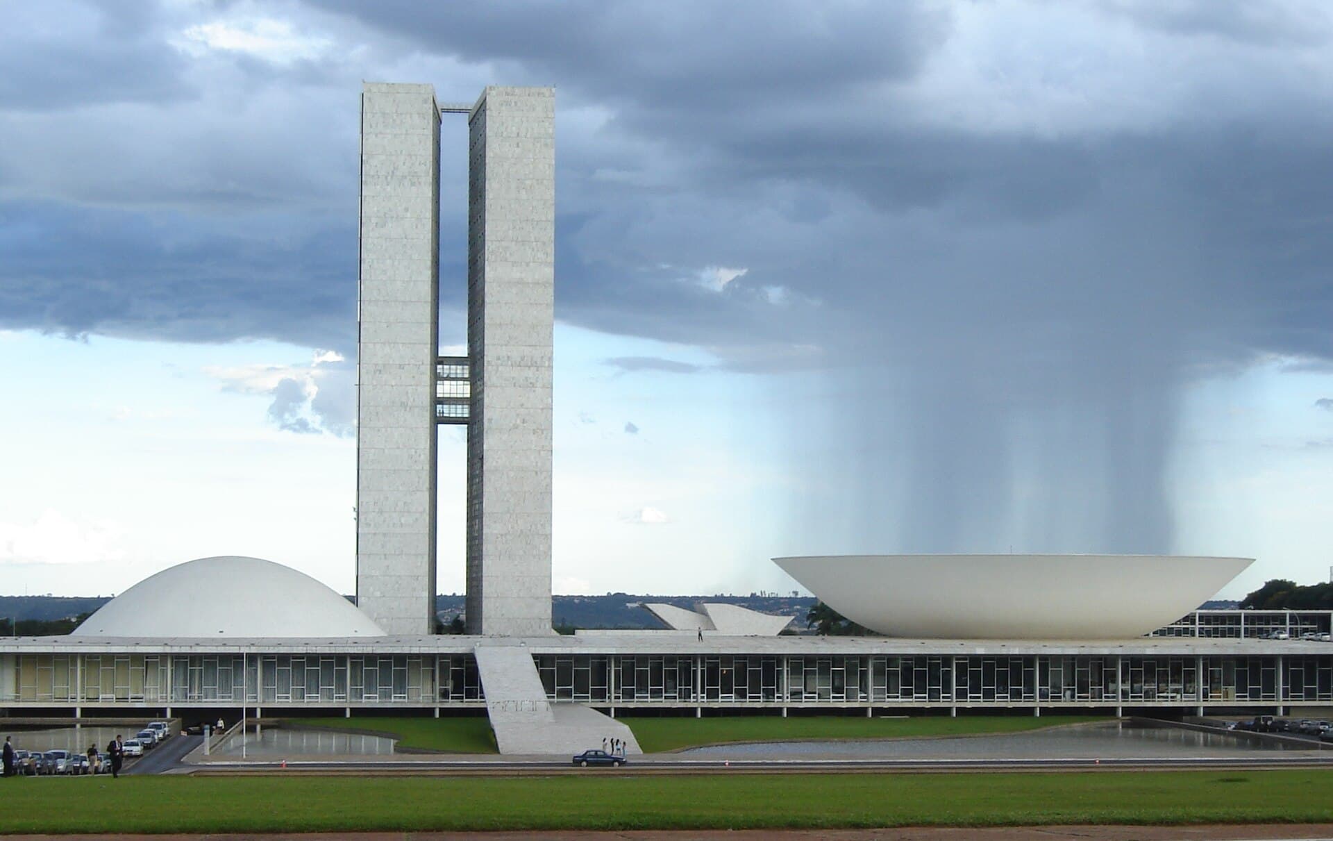
The short answer: Do not walk Brasília as one continuous monument trail. Divide the Plano Piloto into three readings: the eastern Monumental Axis and Praça dos Três Poderes, the central crossing and cultural institutions, and the residential superquadras of Asa Sul or Asa Norte. Put Lake Paranoá on a separate outing. This preserves the logic of the plan without forcing long, exposed transfers between buildings that only look close on a map.
Use the Brasília first-time travel guide for accommodation, food, and broader trip planning. The Brasília destination page connects that guide with this architecture route.
Read the city as scales, not isolated buildings
Iphan explains that Brasília's protected urban ensemble joins modernist architecture, urban design, landscape, and art. The plan separates functions while connecting them through two principal axes and a hierarchy of spaces. A route that photographs only Oscar Niemeyer buildings misses much of what is protected.
Look for four relationships:
- the monumental scale of government and civic representation;
- the residential scale of superquadras and neighborhood services;
- the concentrated commercial and transport areas near the central crossing;
- the open, planted spaces that give distance and horizon to the composition.
These categories are analytical tools, not fences. The useful part is seeing how a cathedral, ministry block, bus platform, residential pilotis, local shop, and tree canopy play different roles in the same plan.
Begin with an official map and mark entrances, not building centers. A palace may occupy a nearby map block while its visitor entrance, security queue, and pedestrian approach sit much farther away.
Group the eastern Monumental Axis carefully
Use one period for the sequence from the cultural complex and cathedral toward the Esplanada and Praça dos Três Poderes. Decide which interiors matter before walking. Government tours can require registration, identification, security, and specific arrival periods. Check each institution's own current visitor page rather than a general tourism article.
The Ministry of Tourism's August 2026 Brasília overview names the Congress, Palácio do Planalto, Supreme Federal Court, cathedral, Esplanada, and Praça dos Três Poderes among the modernist ensemble. That confirms their interpretive relationship, not same-day public access.
Choose at most one government interior for a first route. The exterior sequence, public art, and urban space need time too. If a tour is canceled, keep a nearby museum or exterior study as the fallback rather than crossing the city for another timed booking.
Sun and distance matter along the axis. Carry water, check the forecast, and use a ride between sections when heat, rain, mobility, or construction makes the exposed walk unreasonable. Monumental scale is something to observe, not a test of endurance.
Use the central crossing to understand movement
The meeting of the Monumental and Road axes is more than a convenient midpoint. Observe how bus movement, platforms, shopping, offices, hotels, and civic spaces concentrate around it. The contrast with the quieter superquadras helps explain the plan's separation of functions.
Do this reading in normal urban conditions. Keep valuables secure, follow current local advice, and do not wander into traffic infrastructure for a photograph. Use designated crossings and station access.
The TV Tower area can provide a higher view when its observation facility is open. Confirm access and last admission before building the day around it. A closed viewpoint does not ruin the route; the ground-level relation between the axis, central platform, and surrounding sectors still explains the plan.
If a current official city tour operates, examine its stops and accessibility before booking. Brasília's July 2026 government information described a Rota Monumental and tourist-assistance centers, but schedules can change. Treat that page as a dated service notice, then reconfirm.
Walk one superquadra as a neighborhood
The residential scale becomes legible only on foot. Choose one established superquadra group in Asa Sul or Asa Norte and enter through public paths. Notice the pilotis, building placement, tree canopy, pedestrian circulation, schools, local commerce, and the transition between residential and service areas.
The Federal District's official English visitor guide identifies the 107, 108, 307, and 308 South superquadras as a model neighborhood unit, with residential buildings and local services arranged around the original concept. Use it as a study area, not an open-air museum whose residents become exhibits.
Stay on public routes, keep noise low, and never photograph through apartment windows. Ask before making portraits of workers or residents. Ground floors under pilotis may be publicly passable, but doors, gardens, schools, and condominium facilities can still be private or controlled.
Add Igrejinha Nossa Senhora de Fátima only when its current opening and worship schedule permit a respectful visit. A religious service takes priority over architectural tourism.
Put Lake Paranoá on another route
The lake relates to Brasília's form, leisure, institutions, bridges, and official residences, but its shoreline attractions are dispersed. Choose one or two points and use road transport. Trying to circle the lake after a Monumental Axis day creates a series of car-window views with little interpretation.
Decide what the lake period is for. It might examine the JK Bridge and urban expansion, pair a cultural institution with its landscape, or provide a park break after several interiors. Confirm entry, parking, and public shoreline access for each chosen place.
Do not treat a view of an official residence as permission to approach a restricted area. Follow barriers and security instructions. For water activities, verify the operator, launch point, flotation equipment, weather policy, and accessibility separately from the architecture route.
Build a two-day architecture plan
| Period | Area | What to read |
|---|---|---|
| Day 1 morning | Cultural complex to Esplanada | Monumental sequence and one confirmed interior |
| Day 1 later | Praça dos Três Poderes | Government ensemble, public art, and horizon |
| Day 2 morning | Asa Sul or Asa Norte superquadra | Residential scale, pilotis, trees, local services |
| Day 2 later | Central crossing or one lake point | Movement and commerce, or landscape relationship |
Keep a third day if architecture is the main purpose. It allows another interior, a museum collection, or a second residential area without reducing the route to façades.
For accessibility, contact every interior and tour. Ask about drop-off, security queues, ramps, lifts, seating, toilets, and distances between stops. The open plan can create long routes even when individual buildings have accessible entrances.
Sources checked
Desk research only. Stopover did not walk this route, test public transport, enter the buildings, or audit accessibility on site. Official references were checked on August 29, 2026:
- Patrimônio Mundial no Distrito Federal - Iphan; protected-ensemble history and the relationship among urbanism, architecture, and arts.
- Brasília: única cidade moderna reconhecida como Patrimônio Mundial - Ministry of Tourism; August 2026 official overview of the Plano Piloto, Monumental Axis, superquadras, and principal civic buildings.
- Brasília City Tour Guide - Federal District tourism authority; official English route guide and model superquadra context.
- Ônibus turísticos e centros de atendimento - Federal District government; July 2026 service information for the Monumental Route and tourist-assistance points, subject to reconfirmation.